
About Travel Notes™ Budget Travel City Guides Countries Feedback Regional Travel Videos Travel Writing

Car Hire Cruises Flights Hostels Hotels RTW Tours Vacations Weather Where To
Google+ Travel Notes on Google Plus Add URL to Travel Notes - Advertise on Travel Notes - Link To Travel Notes - New Listings - Travel Blogs - Travel News - Travel Twip - Travel on Twitter.
Subscribe to the Travel Notes Blog Travel Notes: Travel Notes Blog

How Far Can I Travel

Thursday, January 14, 2010

The Official Travel Notes Blog

The other day, while planning a possible cycle adventure around Europe, I was trying to work out how far I could expect to travel each day and how long it would take for me to complete the trip; with one rest day every five.

I couldn't find the right distance calculator for my needs, as most tend to plot straight lines and require you to input the arrival and departure points.

I did manage to plan out the trip, by setting Street View to a 5km scale, and scrolling the map around; noting the places at about one map window distance away from Amsterdam. Continuing the procees for each subsequent day of the journey took a rather long time and is not for the faint of heart.

More about the possible cycle adventure later.

Today I found just the sort of tool I was looking for and just had to share it with you.

How Far Can I Travel
'Discover how far you can travel on land from a fixed point. Specify the start point, then input either how far you can go or your mode of transport with time available. This tool will then show you the range of locations that you can reach in that time'.

Eureka!

To put it to the test, I typed in Amsterdam, selected cycling and estimated 8 hours in the saddle.

There's also an option for speed vs accuracy - I chose 'Medium Accurate (medium speed)'.


Amsterdam to Bruxelles seemed a long way to cycle in a day.

Maybe that's a day's ride for Lance Armstrong but I didn't want to race around with my head down, aerodynamically poised to shave off the most time possible. I wanted to ride more slowly, with my head up; enjoying the sights and the freedom of the road. This thing needed some tweeking.

My initial plan had me cycling from Amsterdam to Den Haag in a day. I figured this would be reasonable and based the rest of the adventure on roughly those sort of distances; depending on what sight-seeing distractions might come up along the way.

To test this again, I needed some points I had cycled before; for real-life, travel-by-bike - complete with ice-creams and picture stops - conditions.

Sopron to Csorna (with a de-tour along Fertő-tó), Csorna to Komarom (rain forced us to take the train from Györ, after spending a few hours in an Internet cafe); Komarom to Esztergom; and Esztergom to Szentendre (after a late start, a visit to the Basilica and a side-trip across the Danube to Vac).

Toggling with the speed and hours I eventually found something that looked about right.


Sopron to Csorna.
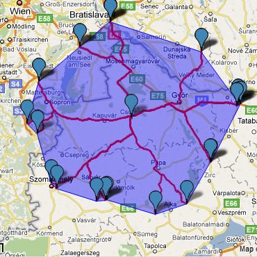

Csorna to Komarom.


Komarom to Esztergom.


Esztergom to Szentendre.

To get these results, I chose running (12km) and 6 hours (with medium accurate).

If this is something you've been looking for too, create your own How Far Can I Travel map.

Labels: , ,

Google Maps

Friday, December 02, 2005

The Official Travel Notes Blog

Google Maps (or Google Local, if you prefer) might not be the first place to go for travel maps and driving directions, as there are plenty of other travel resources out there which have been providing the service longer: MapQuest, Maporama and Multimap among them.

I also like using ViaMichelin online, for planning my drives in Europe, as I have a whole collection of Michelin Maps in my car.

No, what really makes Google Maps interesting is that anyone can get the Google Maps API and embed Google Maps into their webpages using JavaScript (you will need to sign-up for an API key to get started) to pin-point the location of whatever data they chose.

Personally, I found the code a little cumbersome and maps with a lot of pins take a long time to load but I expect Google to make things simpler and faster, especially with the input from the many programmers using Google Maps.

There's also an API Help section, for frequently asked questions, and a Google Maps API Discussion Group.

If you feel overwhelmed when you look at JavaScript, you may want to take a look at Google Maps EZ. You'll still need to sign-up for an API key at Google.

Google Earth is also an interesting application, that you need to download, if you like having a bird's eye view of the world.

So Who's Using Google Maps?

More Google map mash-ups are appearing online every day but these are some of the interesting ones we found.

Celebrity Maps:
Combines the power of Google Maps with addresses found at Celebrity Web. Unfortunately, some of these addresses are the agent's building; like the Creative Artists Agency at 9830 Wilshire Blvd, Los Angeles.

CommunityWalk:
A variety of maps, or 'communities', submitted by users. The locations displayed on a map can be enhanced with photos. Also, the creator of the community can allow visitors to comment on the locations or community as a whole, creating a community of users around each physical community.

Dodgeball:
Focuses on merging location-based services with social networks to help people connect with the people and places around them. (Acquired by Google on May 11th, 2005).

Google Maps Web Cam Locater:
Locations of webcams around the United States.

GMaps Pedometer:
This little hack uses Google's mapping application to help record distances travelled during a running, or walking, workout.

Google Sightseeing:
Not in any way sponsored by or affiliated with Google, this site takes you to some tourist spots around the world via satellite images and maps from Google.

New York City Apartments:
Could this be the future for estate agents and real estate brokers? Browsing property online just got a lot more interesting thanks to this mash-up by CityRealty.

New York City Subway Map:
After loading (it takes a while) you can run your mouse over the New York City subway map to reveal the names of each stop, then click on the icon for MTA info.

Paris Metro:
Click two points on the Paris Metro map to get the best route and estimated travel time.

Pixagogo Photo Maps:
If you don't have the time to code up your own map with photos, you could put your photos on another map online and just link to it.

The Bounty Network:
Find local products and services in the US.

Weather Bonk:
Real time weather information on a map with views of some of the places pin-pointed.

World Heritage Google Map:
Here is a typical example of too many entries on the map (over 800) slowing it down completely, even stalling the browser and locking it up completely in some cases. It's best to select 50 random sites, or choose one country from the drop-down list.

New Google Map Mash-ups

To keep informed on new mash-ups of Google Maps, visit and bookmark Google Maps Mania. Cool Google Maps runs with the same idea.

If you would like us to link direct to your Google Maps mash-up, from the Travel Notes Blog, just tell us about it in the comments.

Labels: ,

Regional Directory - Search The Web - Subscribe to Updates.

Travel Notes Hub

Travel Articles

Michel Guntern on Facebook
TravelTweet on Twitter

Search City Hotels

Search 1800-Hostels


Follow This Blog on Facebook

Join the founder of Travel Notes on Facebook Connect With Travel Notes

Add to Flipboard Magazine

Car Hire Cruises Flights Hostels Round-The-World Specials Tours Vacations
TravelNotes.org: Travel Notes Blog - Toolbar