
I couldn't find the right distance calculator for my needs, as most tend to plot straight lines and require you to input the arrival and departure points.
I did manage to plan out the trip, by setting Street View to a 5km scale, and scrolling the map around; noting the places at about one map window distance away from Amsterdam. Continuing the procees for each subsequent day of the journey took a rather long time and is not for the faint of heart.
More about the possible cycle adventure later.
Today I found just the sort of tool I was looking for and just had to share it with you.
How Far Can I Travel
'Discover how far you can travel on land from a fixed point. Specify the start point, then input either how far you can go or your mode of transport with time available. This tool will then show you the range of locations that you can reach in that time'.
Eureka!
To put it to the test, I typed in Amsterdam, selected cycling and estimated 8 hours in the saddle.
There's also an option for speed vs accuracy - I chose 'Medium Accurate (medium speed)'.

Amsterdam to Bruxelles seemed a long way to cycle in a day.
Maybe that's a day's ride for Lance Armstrong but I didn't want to race around with my head down, aerodynamically poised to shave off the most time possible. I wanted to ride more slowly, with my head up; enjoying the sights and the freedom of the road. This thing needed some tweeking.
My initial plan had me cycling from Amsterdam to Den Haag in a day. I figured this would be reasonable and based the rest of the adventure on roughly those sort of distances; depending on what sight-seeing distractions might come up along the way.
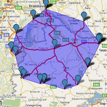
To test this again, I needed some points I had cycled before; for real-life, travel-by-bike - complete with ice-creams and picture stops - conditions.
Sopron to Csorna (with a de-tour along Fertő-tó), Csorna to Komarom (rain forced us to take the train from Györ, after spending a few hours in an Internet cafe); Komarom to Esztergom; and Esztergom to Szentendre (after a late start, a visit to the Basilica and a side-trip across the Danube to Vac).
Toggling with the speed and hours I eventually found something that looked about right.

Sopron to Csorna.
Csorna to Komarom.

Komarom to Esztergom.

Esztergom to Szentendre.
To get these results, I chose running (12km) and 6 hours (with medium accurate).
If this is something you've been looking for too, create your own How Far Can I Travel map.
Labels: cycling, google maps, maps
By TravelNotes @ 15:20
0 Comments
![]()
![]()

0 Comments:
Post a Comment
<< Home